
I remember how tedious using maps to get anywhere was.
Last week I traveled through some rural desert backroads and Apple Maps got me there no problem, but it had taken me on an indirect route. As I was driving I discovered that it was because a number of the roads were completely closed. If I had been using maps I would have had to stop and figure out the detours on my own.
Yup, was a Garmin. Part of me has been a little worried cause i can’t find my way anywhere without GPS anymore, and Google has been getting shittier every day.
Hell, I remember the first time I used maps on a computer to plan and print a route, and the first time I could do it online with MapQuest.
Those were moments that the Internet really felt like the future.
I used to tape maps to the gas tank of my motorcycle on trips.
Then mapquest became useful and I taped printed directions. Made it a lot easier.
Then I got a Garmin waterproof, handlebar mounted GPS and it was glorious, though you had to buy map updates every couple years.
Eventually phones were actually able to be used for directions and I kept a phone connected to a homemade battery pack in my jacket pocket, with an earbud under my helmet, so I just listened to directions and music.
Finally got a phone connected to a handlebar mount, plugged into the bike power, with a Bluetooth headset built into the helmet. Probably the least safe of the options, but I can listen to podcasts, audiobooks, music and see the maps while it directs me with audio, just like a car display would.
I rode from the UK to northern Italy with nothing but an early hiking go’s unit that had no map. Just an arrow pointing to Torino. The trip over the Alps was very random.
Didn’t mapquest get sued for routing people through a dangerous neighborhood? Then they started putting a disclaimer?
On my first smart phone ca. 2014, I had Here Maps (a Nokia product I think?). I didn’t have any data plan, and that mapping service didn’t require it. I don’t think I ever used it, but that may be the first. Otherwise, earlier this year I used my work phone and whatever it has for navigation. I hated it 😅 I clearly liked knowing directions more then one turn out.
I did pizza delivery for years without GPS.
We had a really early one in the 90s, like way earlier than anyone else we knew, in a car we bought from some rich guy. We only used it once or twice as a novelty as my Dad always insisted he knew better. Plus it had its maps loaded up using some CD which was really out of date and it wasn’t like you could type in McDonalds and it would take you to the closest one, you had to put the whole address in and even then I think it wouldn’t find it half the time.
The first one I got was a gift in the 00s and it was bloody awful. Once I t turned me off a perfectly straight road to drive through a graveyard and then put me back on the road I had been on. Another time it turned me off and sent me down the only toll-road in the UK, then got me off at the first exit and put me back on the toll-road in the opposite direction to get me off at the place I’d got into it earlier. I had to pay twice to go nowhere and it added five minutes to my journey.
Just to add, when people came round our house in the late 90s my Dad would make me turn on the computer to show them MS Autoroute, which was an offline piece of software that was used to generate routes, basically what Google Maps does now with directions, but it would just give you something to print out. Really useful for the day and you could even get it to estimate how much the fuel would cost, etc.
It tells you which direction something is in, but can’t help plot a route to get there.
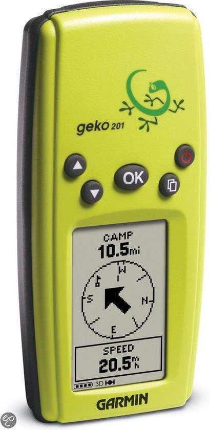
I still use my Garmin Geko even now. Useful as a basic device recording a track I can geocode photos with, and runs for days on two AAA batteries. In a pinch you can reverse a track and go back the way you came too 😅
That’s such a good idea. My camera has to pair with my phone to get GPS readout and it’s a nightmare app. Going to look into this
Nice device!
I still remember printing out google maps directions, then missing one turn and then being completely lost.
The number of times I had to stop and recalibrate with the paper map was high!
I used to geocache this way because I couldn’t afford a GPS. Finding caches took some time!
Internal thought process: “psh, it’s not just over-35’s who remember the dawn of GPS, I’m only… thirty… six…” 😩
I don’t have deeply shocking memories about using GPS for the first time, it was just this gadget my dad got for road trips so we didn’t have to deal with an atlas. However, I still remember being a passenger in a moving car using my first smartphone, watching our progress on Google Maps and feeling like I had gained the ability to see around corners. Technological progress seemed unambiguously positive and my phone just kept getting more useful.
Yeah! My parents had a garmin or the like. Mother downloaded some voice pack for it, I forget who it was of. We still had papery maps with us, in case.
My first GPS was an entire laptop sitting in the passenger seat with a card adaptor. Then I upgraded to a PDA (remember those?) with a card adaptor (may have been the same one, I can’t remember). Motorcycled over 3000 miles with that setup before smart phones became a thing.
First time I ever used one was 2004 following the grateful dead on an east coast tour.
One nice benifit was we’d come into town from the opposite direction of the caravan, avoiding a ton of traffic and finding the back route to the venue. Almost always got us better parking and way shorter lines into the lot.
Alternate question: do any of you (maybe a bit older than 35) remember the last time you bought an updated paper map for your area, or one for a road trip? They used to be at most checkout lanes in many stores.
I can already hear the “maps on paper? How could you find anything?”
Yes, I get paper maps of my area. For hiking, but I think it still counts.
The last time I used a paper map for driving? Probably early aughts
I would guess that hiking or trail maps are probably much more detailed than a road map, so that makes sense that it would still be a thing, although certainly digital versions have made some dent in them. Electronics are a bit more susceptible to the environment and the need for power though, so maybe not as much for those reasons.
Yep, right on. For a day hike or simple trail, I’ll trust my phone maps and Garmin GPS. Anything beyond that, I’m bringing a map and compass as a backup because they don’t require power and the good ones still work even if wet.
Even for a simple day hike, I’ll usually print out a map because it’s quicker than using my phone.
Maybe five years ago?
I like having paper maps in the “oh shit” bag
No, because if I need information I stop at information places at the border and get a map for free. Sometimes you can get whole guidebooks full of maps and directions and interpretive information for free. I picked up maps or guidebooks multiple times this year.
Yeah it was a USB dongle, I think Garmin made it, and it was a huge pain to set up. Power inverter into the car charger, laptop into the power inverter, Garmin dongle into the laptop, load up the software and wait like 10 minutes for it to triangulate itself with glonass or whatever other satellite options were in there. After that it worked pretty well, but most of the time I could get to where I wanted to go before it could figure out where I was.
The original Droid was the first one I had that really impressed me, basically because of how much nicer it was than that previous experience. Now I just had to pull out my phone and launch the app, and it was accurate to within a few feet instead of a few meters! Still took them a few years to update Google maps with a lot of the new subdivisions in the area, but for a novelty navigator it was pretty cool.
I couldn’t tell you the specifics, but back in the 1990’s, we had GPS devices that just had an LCD read-out of your latitude and longitude, so you could find your position on a paper map. They were on the market as survey devices, but were also useful for wilderness travelers.
It’s hard to recall exact dates, because the devices developed incrementally, and navigation mode on Google Maps didn’t spring into existence ask at once.
I remember being really amazed that I could stand in place and turn around and see my arrow on google maps turn with me. It seemed crazy it had that much precision.
They don’t. There’s typically a compass in phones that provides information useful in determining direction.
https://en.wikipedia.org/wiki/Magnetometer
Mobile phones
Many smartphones contain miniaturized microelectromechanical systems (MEMS) magnetometers which are used to detect magnetic field strength and are used as compasses. The iPhone 3GS has a magnetometer, a magnetoresistive permalloy sensor, the AN-203 produced by Honeywell. In 2009, the price of three-axis magnetometers dipped below US$1 per device and dropped rapidly. The use of a three-axis device means that it is not sensitive to the way it is held in orientation or elevation. Hall effect devices are also popular.
Oh interesting. I guess it makes sense. Much simpler solution with high accuracy.